A Brief History of Easton, Connecticut
“This brief history of our town of Easton, CT has been researched and written for this website primarily from source material provided in an extensive study of the history of the town. That study was completed in May, 2009. It is entitled “Historical and Archeological Assessment Survey of Easton, Connecticut. The study was done by Stuart Reeve, PH.D, David Silverglade, M.A., and Kathleen von Jena, B. A. of Aspetuck Landways. It was partially funded by a grant from the Connecticut Trust for Historic Preservation, in cooperation with the Connecticut Humanities Council. The resulting document fills a 3 1/2” binder with single spaced type in a small font, each page printed on one side. In all it is comprised of more than 600 pages of text, tables, lists, and illustrations.
It should be made clear that in no way is this brief history of the town an attempt to summarize that thorough and comprehensive document. Rather the document served as source material along with some additional secondary Internet research, conversations with some of Easton’s long-time residents, some additional illustrations taken from the Internet, and photographs obtained from local sources. Throughout this little history that study will be referred to as the Aspetuck Landways Study or Survey when referenced. This article is not intended to cover all aspects of the town’s past, but to focus on the primary influences that came into play to make Easton what it is today.
It is our hope that this little tale of our town will answer some questions but more importantly that it will prompt many questions and encourage readers to learn more about the history of Easton.
Tom Spurr
How Did the Easton, CT of Today Come to Be What It Is?
If one posed the question, “What were the primary elements that shaped the Easton of today?” the answer could be stated with four words or phrases: glaciers, English settlers, the Industrial Revolution, and Bridgeport Hydraulic Company. But that wouldn’t really be informative or interesting, so this brief history of our town will expand on that cryptic answer in an attempt to explain how and why we have the Easton, Connecticut of today.” – pg. 1
“The last glaciers left the area that now comprises Connecticut and New England about 17,000 years ago.”

“Somewhere between 12,000 and 10,000 years ago the first humans showed up in the area that we now call Easton, Connecticut. How did that happen? Well they didn’t take Metro-North.”

“We have records of interaction between the natives and the settlers but with few names and few archeological artifacts or dwelling sites. One name that has survived was a Native American leader whose name was Crecroes (Anglicized from the Algonquin). A battle took place in the area that is now Southport in 1637, known as the Great Swamp Fight. The natives were from a group called the Pequonnocks, an Algonquin-speaking group, made up of five separate groups or bands. One of those bands, the Aspetucks, settled in an area called Great Swamp or Middlebrook Swamp in what is now Easton, somewhere along current day Cricker’s Brook, perhaps now beneath the Hemlock Reservoir. Aspetuck means “high place” and refers to the “up land” elevation of their settlement compared to areas closer to the coast where the other bands settled. Initially, following the battle, leadership was attributed in documents and oral history to a Native American man named Romanock who died in 1760, but the natives disputed his leadership and leadership passed to Crecroes. He remained instrumental and his name is on many deeds including a 1670/71 document, The Northfield Deed, that passed a large part of the ownership of the area that is now Easton to the town of Fairfield.” – pg 4
“Following the Pequot Swamp war between the Native Americans and the English in 1637, Fairfield and Stratford were settled by 1639. The city of Bridgeport, and the towns of Trumbull, Shelton, and Monroe were non-existent at the time as were the towns of Easton and Weston. Parts of what were then Stratford and Fairfield eventually became Easton and southern Redding. In 1667 The Connecticut Colony ordered a survey of the boundary of Stratford and Fairfield to settle land disputes. The northern boundary of Fairfield was set at the current site of Cross Highway in Redding. That survey affects areas of Easton down to the present day.” – pg 5
“In 1670/71, the natives Crecroes and James, another native Sachem (chief), signed deeds with the town of Fairfield and the Pequonnocks signed similar deeds with Fairfield and with Stratford. This purchase by Fairfield from the natives secured “the last six miles of the town common” of the Native Americans’ land holdings in the area for the sum of 36 pounds sterling. Fairfield’s purchase included what is now northern Fairfield, Easton, Weston, and southern Redding. The Stratford purchase included what is now Bridgeport, Shelton, Trumbull, Monroe, and eastern Easton. These remote northern areas were not settled for quite a few years.” – pg 5
“Settlement of present day Easton by Europeans began early in the 18th century or perhaps at the very end of the 17th century. By 1704 Captain John Davis had built a sawmill on The Aspetuck River at what is now Old Redding Road. That sawmill is still an item of interest locally, due to a small mill building replica built there in 1935, after the old mills had lost their usefulness and were dismantled.

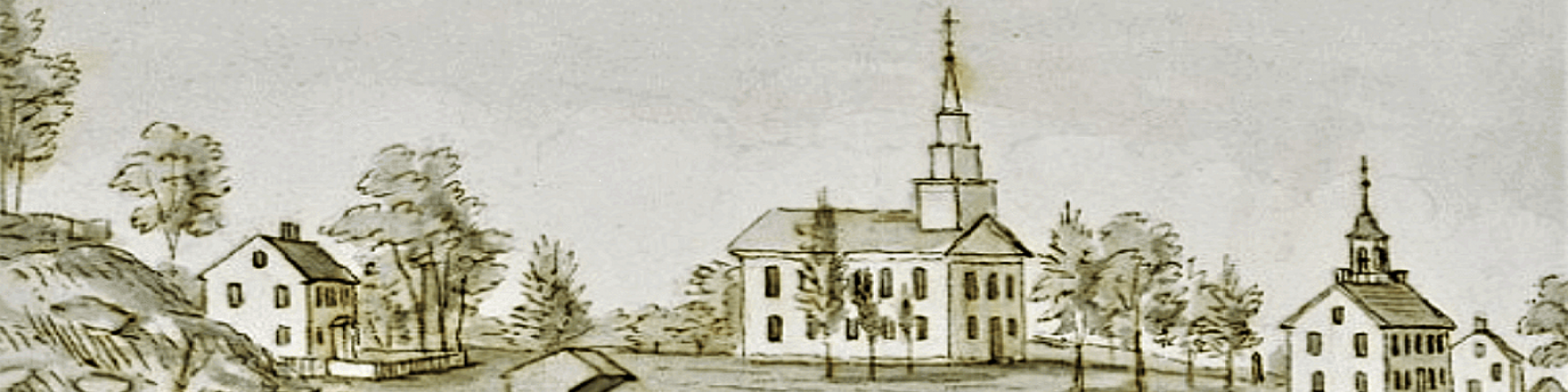
This part of Easton, known by both the names Aspetuck and Gilbertown was the first part of town that was settled. It is the area of Redding Road, Old Redding Road, Westport Road (CT Route 136), a small portion of Wells Hill Road, originally known as Bradley Highway, and up to the location along Black Rock Road (Route 58) where the Bluebird Inn and Bluebird Garage stand. The Gilbertown Cemetery, one of the areas oldest, adjoins Aspetuck Park today along Black Rock Road near the intersection with Redding Road. The headstones there date back to 1779.” – pg 7
“Some New England towns took on a form that came from medieval times in which residents lived in near proximity to one another, always with a meeting house/church and a town green at the center of things, houses and gardens surrounding with fields farther away. Wood lots and other areas were held in common. Easton didn’t develop that way. It may have had to do with the terrain and with the primary occupation of its residents in the 18th century, mostly subsistence farming. The term “subsistence farming” refers to the planting and harvesting of crops and the keeping of animals (animal husbandry) for the primary purpose of feeding one’s family rather than as a commercial enterprise. In the absence of coinage or other currency, of course some of these food products and clothing products were bartered with other locals for services such as blacksmithing or milling or for other goods or products that the particular family was not producing on their farm. As we have seen, roads were scarce and crude and all transportation at the time was provided by animals or human legs in the absence of navigable waterways. The farmers and the craftsmen and millwrights that traded with them needed to be close to one another. The scattered nature of the town’s mills and the scattered nature of the subsistence farms, mostly of a small number of acres each might have been the reason that no concentration of population ever occurred in any one place in Easton. There were small concentrations near the sites of the mills but as mentioned above, no one place ever became a large center of town. Over time the farming output of Easton became more of a commercial production but faded as the middle of the 19th century came upon us.
The Easton of the 19th century was a much busier place in terms of commerce than it is today. Easton’s mills were scattered around on the streams that powered the town’s early economy, the Mill River, The Aspetuck, Cricker’s Brook, Tatatuck Brook, and others.” – pg 10
“Cottage industries morphed into factories. Wagons were supplanted by railroads. Farmers sought larger farms in New York, Vermont, and in the Midwest. Easton’s mills had lived out their usefulness. The availability of jobs in the nearby city of Bridgeport in particular changed Easton’s population. It is interesting to note in examining the table above that in the early part of the 20th century, Easton’s housing count went up while it’s population changed hardly at all. That means that households had gotten smaller. Fewer two and three generation households remained. In 1910 the average household size according to the table above was 3.9. In 1950 it was 2.9. In 1851 it had been 5 members per household on average.” – pg 13
“The waterpower of Easton’s streams and rivers was replaced with steam engines and later gasoline and diesel engines and electric motors. The small village type shops of Easton that had produced shoes and iron implements, clothing, and foodstuff were being replaced by much larger factories and larger farms elsewhere. The very nature of Easton’s land, which had been such a nice advantage in the 18th century for subsistence farming and water-powered cottage industry was becoming a liability in the new age.” – pg 14
“At the beginning of this tale the question was posed, “What were the primary elements that shaped the Easton of today?” The answer named four things; glaciers, English Settlers, Industrial Revolution, and Bridgeport Hydraulic Company. The answer could have been shorter. It could have been two things, hydrogen and oxygen, two primary elements, or shorter yet, one word, “water.”” – pg 15
“So how did Easton get to be the Easton that we have today? The glaciers arranged for the water, the settlers established a rural community with very high standards for education. We still have a school system that ranks among the best in the country. The water provided power for our forefathers, and now the water keeps our town looking wonderful and pays a big chunk of the bill. Aquarion Water Company, formerly Bridgeport Hydraulic Company, is by far our largest taxpayer in Easton.” – pg 16
“That’s how Easton, Connecticut came to be Easton, Connecticut – water.”– pg 18
You should include credits for graphics, quotes and information.
Steve I thought I had done that. Most of the graphics and information is of course from the Aspetuck Landways Survey and I made that clear and quoted where exact quotes were used. I’ll take another look at it. Thanks for the tip.
Tom Spurr
I was told there was a time when part of Easton, which includes Flat Rock Rd., was part of Weston. Do you know anything about this
Christine, prior to 1845 all of Easton was part of Weston. In 1845 Easton became a separate political entity from Weston. If you have any other questions, please don’t hesitate to ask.
Tom Spurr
Lived in Easton from October 1979 to late March 1998….wish I could live in Easton or Redding. Love the website, thank you for a great website and a look at the history! Best Wishes! Kevin 🙂 <3
Can I get the address as to where Helen Keller lived? Do you have photos of her house?
Barbara, her home was the one at 163 Redding Road. The driveway enters from Redding Road right at CT 136 aka Westport Road and the house actually faces Westport Road. That is the second home that she had at that site. The initial house burned down in 1946 while she was away in Europe doing charitable work related to WWII.
If you go through the “Recent Events” section of the Historical Society Website you will find a feature article about the relationship between Mark Twain aka Samuel Clemens, and Helen Keller. The homes were gifts to her of the wealthy businessman Gustav Pfeiffer, Chariman of The Warner Lambert Company. If you pick up a copy of this next week’s Easton Courier (comes out on Thursday and you can find it at The Easton Village Store) the edition will feature a story about Gustav Pfeiffer, who left a remarkable legacy in Easton.
In the Hellen Keller/Mark Twain feature there are two photos. One is of the two of them together and one is a photo of her at her home in the yard but there is not an actual photo of the house.
Thank you very much for this information. I have posted it on Dan Woog’s blog, 06880. There is certainly a lot of misinformation out there about where Helen Keller lived. Thanks for clarifying this.
If I were searching for genealogy records on a family that was listed in the 1790 census as living in Weston but christened some of their children in the Easton Congregational Church, which Historical Society should I start looking, Weston or Easton? What are your hours?
Thank you for your inquiry. Easton and Weston were originally part of Fairfield. In 1762, the congregation of North Fairfield was created for this area. In 1787, North Fairfield was incorporated into the town of Weston. Easton broke away from Weston in 1845. Weston’s town library, town hall, and historical society would hold the records you seek, based on the year in question (1790). Mr. Jonathan Stock, historian of the Congregational Church of Easton, has all of the church records on file. If the family you seek was baptized there, he should be able to help you with some information, too. You can reach the church by phone at 203-261-2527
Traveling through your area and noticed Freeborn Road. Curious about the history.